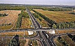
In the east of Moscow, there is a place where the Entuziastov highway is crossed by the Moscow Ring Road from above. From there begins the federal highway M7, also called the "Volga", and also "Peking". This highway, 1351 km long, counting from the center of the capital, is the shortest road route from Zlatoglava to the Volga region. What was the result of the construction of the Moscow - Ufa highway, which began even before the appearance of the first car with an internal combustion engine on Earth - further in the review.
A brief history of the M7

Even during the reign of Prince Yuri Dolgoruky, active laying of paths leading from Moscow to the east began. A new round to this process was given by the decision of the transport authorities, dating back to 1840, to build a highway from Pervoprestolnaya to Nizhny Novgorod, which was later transformed into M7. The route was intended to reduce the distance that merchants had to cover to travel between these cities. Managers were appointed to carry out the project, road builders were involved, and the business boiled over.
A supply of stone was organized to the construction site of the highway, bulk work began, the road was covered with lime crumb. In 1843, the first postal stagecoaches drove along the new track. But not everything went smoothly. Due to the poor quality of the pavement, the Nizhny Novgorod section of the highway was soon closed, and the carriages returned to their usual route - along the right bank of the Oka.
And "overhaul" began on the Moscow highway. From the banks of the Sheksna River, local serfs transported cobblestones for the road. But there was not so much of it, because the canvas was mainly covered with crushed limestone, and even then only one strip, and, moreover, in a significantly smaller layer than it was supposed to. On the other hand, bridges of the required height were erected across the rivers that meet on the road.
By the way, the Nizhny Novgorod city government did not lose from the construction of the highway. For each square fathom set aside for the highway, local authorities received a ruble and a quarter. The jury appraisers said that this price is very reasonable. In turn, the work of the coachmen was paid at the same rate for the entire Nizhny Novgorod province, which was 1.5 kopecks per mile. This was a pretty decent remuneration, compared, for example, with the income of a farmer, which was 10 kopecks a day.
In the summer of 1845, along the Moscow highway, the construction work on which had not yet been properly completed, trade goods moved to Nizhny Novgorod. According to the "Military Statistical Review of the Russian Empire", the section of the route belonging to the Balakhninsky district stretched for 52.5 miles, over a fairly flat area, mainly occupied by dense forest, mostly swampy, and occasionally met with stations and inns.
The annual traffic of the road was not that big at that time - up to 30 thousand horses, for which "highway money" was charged.
Well, the movement of cars on the Moscow highway actually opened with the revival of the Nizhny Novgorod fair, on August 1, 1922. It turned out to be cheaper to transport goods by road than by rail, so the route turned out to be in great demand. True, this happened periodically. Regular flights were sent only from the Rastyapinsky Explosion Plant.
During World War II, the Moscow highway was actively used to supply the front with guns and ammunition. And after the end of the war, the track again needed serious repairs, which began in 1954.
In ten years, the highway has been radically rebuilt. The pavement of cobblestones was replaced with concrete, the route became straighter, road junctions and detours of some cities appeared on it. The sections of the road near Moscow and Gorky were made more spacious, with a four-meter dividing tape and 2.5-meter wide shoulders. This modernization has led to a significant increase in driving speed, moreover, the ride has become safer.
The development of friendly relations between the USSR and China in the 1950s led to the prospect of forming a transcontinental Moscow-Beijing highway from the Volga highway. Hence the name "Peking". Unfortunately, the road to the Chinese capital was never completed. By the way, in the 1970s, the highway was designated by the index 8; it received the name M7 in the mid-1980s.
Bridges and ferries on the Volga

In 1962, near Myachkovo on the border of the present Vladimir and Nizhny Novgorod regions, a Klyazminsky bridge, consisting of five spans:
- two reinforced concrete at the edges;
- three metal ones - over the river bed.
And after the Chuvash Tyurlema, the road used to lead to Tatarstan, then again "ran" to Chuvashia about 9 kilometers, and again - along the Kazan land, to the ferry crossing along the Volga, from Nizhniye Vyazovyh to Zelenodolsk. The water section of the route was served by two ferries, which could be loaded not only with cars, but also with trucks.
The opening in 1990 of a bridge across the Volga, connecting the Morkvash and Zaymishche embankments, significantly changed the route of the route. M7 has acquired a new site that runs through a picturesque area and another bridge, this time crossing the Sviyaga River near the village of Isakovo in Tatarstan.
However, the former ferry at Nizhniye Vyazovy continues to operate, only with one ferry. And in winter, ice traffic opens up there for cars. For some time, the path of the M7 highway in Chuvashia and Tatarstan was completely indicated on the maps by two routes:
- former: via ferry from Nizhniye Vyazovy;
- the current one: on the bridges over the Sviyaga and the Volga.
It is worth noting that the emergency state of the aforementioned Klyazminsky bridge led to its closure for vehicles in 2001. The movement was directed along a similar structure freshly built on the left. During the repair of the main bridge, its “native” channel spans were preserved, and the outer reinforced concrete ones were replaced with metal ones.
The length of the renovated bridge across the Klyazma, reopened for motorists in November 2005, was 314.17 m. The width of each of the four lanes of the route passing through this structure is about four meters.
M7 today

Now a wide modern highway runs from the MKAD bridge and up to Nizhny Novgorod, equipped with fenders in the middle, which not only separate traffic flows, but also significantly increase driving safety. The M7 highway runs north of the M5 highway and includes three sections of the following European routes:
- PE2 - from Moscow to Nizhny Novgorod;
- E22 - from Moscow to Kazan;
- E017 - from Elabuga to Ufa.
About 100 thousand cars leave Moscow on the Volga highway per day. Such traffic often causes many kilometers of traffic jams at the beginning of the highway, from the Entuziastov Highway to Balashikha. The excellent condition of this section of the road is a little consolation for drivers who complain that "the M7 will stand if it never arrived." In addition, repair work on the G7 is not uncommon.
Traffic intensity, usually high in the easterly direction towards Nizhny Novgorod, slightly decreases on the further journey to Kazan. After this settlement, the road generally turns into a four-lane format.
Areas of wooded and swampy terrain, steppes and small hills are what the landscape of the highway is rich in. In the Moscow and partly Vladimir regions, the road runs through the swamps of the Meshchera lowland. As for the infrastructure of the M7, there is complete freedom for motorists here. Only on the section from Moscow to Nizhny Novgorod can be counted more than one and a half thousand different establishments, among which there are hotels, motels, cafes, and, importantly, car services.
And by 2024, it is planned to launch an alternative to the M7 - the M12 Moscow-Kazan toll highway, which will have no traffic lights or pedestrian crossings. Among other things, the new highway should somewhat relieve the Volga highway.
Features of the coverage of the M7 highway

Within the Moscow Region, the highway is distinguished by an improved asphalt concrete surface and consists of at least four lanes, each of which is at least 3.5 m wide. This section is rather flat, although there are slight elevation differences in river valleys and on overpasses. The route here is straight, perhaps, with the exception of the 52-kilometer section at the intersection with the A-107 highway and the right turn in the east of Noginsk.
The rut of the pavement, which is high on the part of the road near Moscow, is reduced to barely noticeable closer to Vladimir. Further to Ivanovo, the M7 is in excellent condition.
Numerous irregularities and brigades of road workers struggling with them are what can be found on the way from Ivanovo to Kazan. Perhaps the worst quality of M7 coverage in this area is in Chuvashia. Closer to the capital of Tatarstan, the state of the canvas becomes much better.
Drivers traveling on the Volga highway should pay special attention to areas in front of bridges, where serious bumps or potholes are not uncommon. Such deformation of the road can be caused by watercourses that have changed their direction as a result of construction, or high humidity. As the saying goes, "water wears away a stone."
Advantages and disadvantages of the M7 Volga highway

Benefits:
- free;
- short distance between points of departure and arrival;
- in general, high-quality coverage;
- rich infrastructure;
- picturesque area.
Disadvantages of the M7:
- a third of the road passes through settlements, hence the speed limit, as well as possible delays at traffic lights;
- frequent traffic jams;
- chronic repair.
Conclusion
For its almost 180 years, the Volga track, to be sure, has seen a lot. And although the wagons that roamed along it have long been replaced by loaded wagons, this highway remains very interesting for tourists. If time and dimensions of the car permit, the traveler can turn off the bypass road and find the Golden Gate in Vladimir or the Kremlin in Kazan, and after driving to the south of Ufa - the old Officers' House. Well, and perhaps the main attraction on the highway is the location of the Nizhny Novgorod Fair - the event that gave birth to the M7 highway.

|| list |
- A brief history of the M7
- Bridges and ferries on the Volga
- M7 today
- Features of the coverage of the M7 highway
- Advantages and disadvantages of the M7 Volga highway
|| rss | In the east of Moscow, there is a place where the Entuziastov highway is crossed by the Moscow Ring Road on top. What the construction of the Moscow-Ufa highway, which began even before the first car with an internal combustion engine appeared on Earth, led to what the review will follow. Managers were appointed to carry out the project, road builders were involved, and the business began to boil .__ NEWL__ A supply of stone was organized to the construction site of the highway, bulk work began, the road was covered with lime crumb. Due to the poor quality of the pavement, the Nizhny Novgorod section of the highway was soon closed, and the carriages returned to their usual route - along the right bank of the Oka .__ NEWL__A "overhaul" began on the Moscow highway. On the other hand, bridges of the required height were erected across the rivers that meet on the road .__ NEWL__By the way, the Nizhny Novgorod city government did not lose money from the construction of the highway. It was a pretty decent remuneration, compared, for example, to the farmer's income of 10 kopecks a day .__ NEWL__ In the summer of 1845, commercial cargoes moved to Nizhny Novgorod along the Moscow highway, construction work on which had not yet been properly completed. According to the "Military Statistical Review of the Russian Empire", the section of the route belonging to the Balakhninsky district stretched for 52.5 versts, over a fairly flat area, mainly occupied by dense forest, mostly swampy, and occasionally encountered stations and inns .__ NEWL__Annual traffic the road was not so big then - up to 30 thousand horses, for which “highway money” was charged .__ NEWL__ Well, and the movement of cars on the Moscow highway actually opened with the revival of the Nizhny Novgorod fair, on August 1, 1922. Regular flights were sent only from the Rastyapinsky Explosion Plant .__ NEWL__During the Second World War, the Moscow Highway was actively used to supply the front with guns and ammunition. And after the end of the war, the highway again needed serious repairs, which began in 1954.__ NEWL__For ten years, the highway was radically rebuilt. This modernization led to a significant increase in speed, besides, driving became safer .__ NEWL__Development in the 50s of the last century of friendly relations between the USSR and China led to the prospect of forming a transcontinental Moscow-Beijing highway from the Volga highway. By the way, in the 1970s the highway was designated by the index 8, it received the name M7 in the mid-1980s .__ NEWL__Bridges and ferries on the Volga __ NEWL__In 1962, the Klyazminsky bridge was erected near Myachkovo on the border of the present Vladimir and Nizhny Novgorod regions, consisting of five spans: __NEWL__two reinforced concrete along the edges; __ NEWL__three metal - over the river bed .__ NEWL__A after the Chuvash Tyurlema, the road used to lead to Tatarstan, then again "ran" into Chuvashia for 9 kilometers, and again - along the Kazan land, to the ferry crossing along the Volga, from Nizhniye Vyazovy Zelenodolsk. The water section of the route was served by two ferries, which could carry not only cars, but also trucks .__ NEWL__Opening in 1990 of a bridge across the Volga, connecting the Morkvashi and Zaymishche embankments, significantly changed the route of the route. M7 has acquired a new section, which runs through a picturesque area and another bridge, this time crossing the Sviyaga River near the settlement of Isakovo, in Tatarstan .__ NEWL__ However, the former crossing at Nizhniye Vyazovyh continues to operate, with only one ferry. For some time, the route of the M7 highway in Chuvashia and Tatarstan was indicated on the maps by two routes: __ NEWL__previous: via the ferry from Nizhniye Vyazovy; __ NEWL__current: across the bridges over the Sviyaga and Volga .__ NEWL__ It is worth noting that the emergency state of the mentioned Klyazminsky bridge led to its closure for vehicles in 2001. During the repair of the main bridge, its "native" channel spans were preserved, and the extreme reinforced concrete ones were replaced with metal ones. passing through this structure - about four meters.